
Thank you for visiting this consultation website.
Gallagher Developments is undertaking a pre-application consultation on plans for a high-quality, residential development of around 300 new homes, including landscaping, play areas, and open space.
The new neighbourhood will be set within an extensive green framework that achieves at least 10% biodiversity net gain and promotes active and sustainable travel. The masterplan will respond sensitively to the site’s landscape setting, retaining and enhancing mature vegetation, creating new high-quality habitats, and delivering nature-led and multi-functional public spaces that promote health, wellbeing and inclusive community life.
We value local knowledge. Please take your time to review these proposals and to fill in the feedback section.
The Site
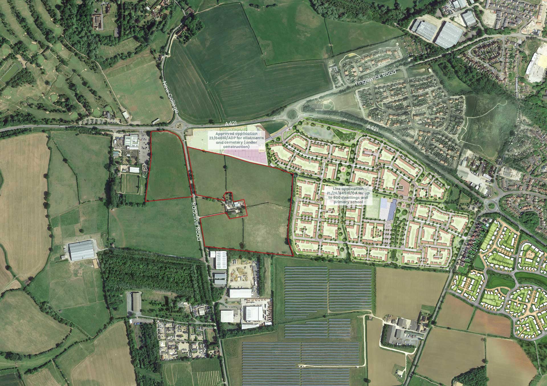
The 15ha site is located to the east and west of Radclive Road. It is well connected to Buckingham town centre, local schools, services and public transport. Positioned immediately west of the emerging development of Buckingham Neighbourhood Plan Allocation HP3, the site location will enable a comprehensively planned extension to the town.
Planning Context
Buckinghamshire’s Development Plan comprises documents covering the former district areas. The site at Radclive Road lies within the former Aylesbury Vale area, where the relevant document is the Vale of Aylesbury Local Plan 2013–2033, adopted in September 2021.
Buckinghamshire Council is currently preparing a new Local Plan and is gathering evidence to assess sites for development. Evidence published in the Buckinghamshire Local Housing Need Assessment (ORS; June 2026) indicates that at least 90,000 homes will need to be planned for Buckinghamshire over the 2024–2045 plan period, equivalent of over 4,300 per year. The emerging Buckinghamshire Local Plan is due to be submitted by 31 December 2026, with adoption targeted for the end of 2027.
Buckingham Town Council adopted its Neighbourhood Plan (NP) in March 2026 and allocated ‘Land to the South West of Buckingham’ under Policy HP3, for a mixed-use development of around 800 homes, including a new primary school and a local centre. Emerging development proposals for Land to the South West of Buckingham have been submitted to Buckinghamshire Council under ref. PL/26/04516/OA and are awaiting determination.
The site lies within Gawcott with Lenborough Parish, where there is no adopted or emerging Neighbourhood Development Plan. The site’s eastern boundary adjoins the Buckingham NP allocation. The site offers an immediate opportunity to help meet Buckingham’s housing and infrastructure needs.



Concept Masterplan
The proposals have been designed to integrate with the planned Neighbourhood Plan Allocation HP3: Land to the South West of Buckingham, with its primary school, local centre and wider green infrastructure network. The layout prioritises active and sustainable travel, including opportunities for pedestrian and cycle links into HP3, the wider Buckingham Green Ring, and National Cycle Network Route 50.
A comprehensive green infrastructure framework retains and enhances existing trees and hedgerows within the site, introducies new habitats, and
incorporates sustainable drainage features to manage surface water and create biodiversity-rich spaces. Public open spaces, play areas, and landscape corridors are positioned to complement HP3’s green spaces, providing an opportunity for a continuous network of accessible routes and recreational areas for future residents.
The proposals present an opportunity to create a vibrant new community, with nature-led public spaces and sustainably designed homes on the edge of Buckingham, an area identified as a focus for new growth.
Our Proposals Include:
- A residential development of up to 300 new homes;
- A variety of house-types to reflect the Council’s identified housing need;
- 40% of the new homes provided as affordable housing;
- Vehicle access to both areas of development from Radclive Road;
- Pedestrian and Cycle infrastructure improvements on Radclive Road and the A421;
- A mobility hub with the potential for e-bike provision, delivery lockers, and a car club;
- Active Travel (foot and cycle) routes around and through the site with potential connections to adjoining developments;
- Connections to the existing Public Right of Way;
- A generous provision of public open space, including children’s play areas and the potential for community orchards;
- Provision of Biodiversity Net Gain;
- Sustainable Drainage Systems;
- Financial contributions to support local infrastructure and accommodate the needs of development.
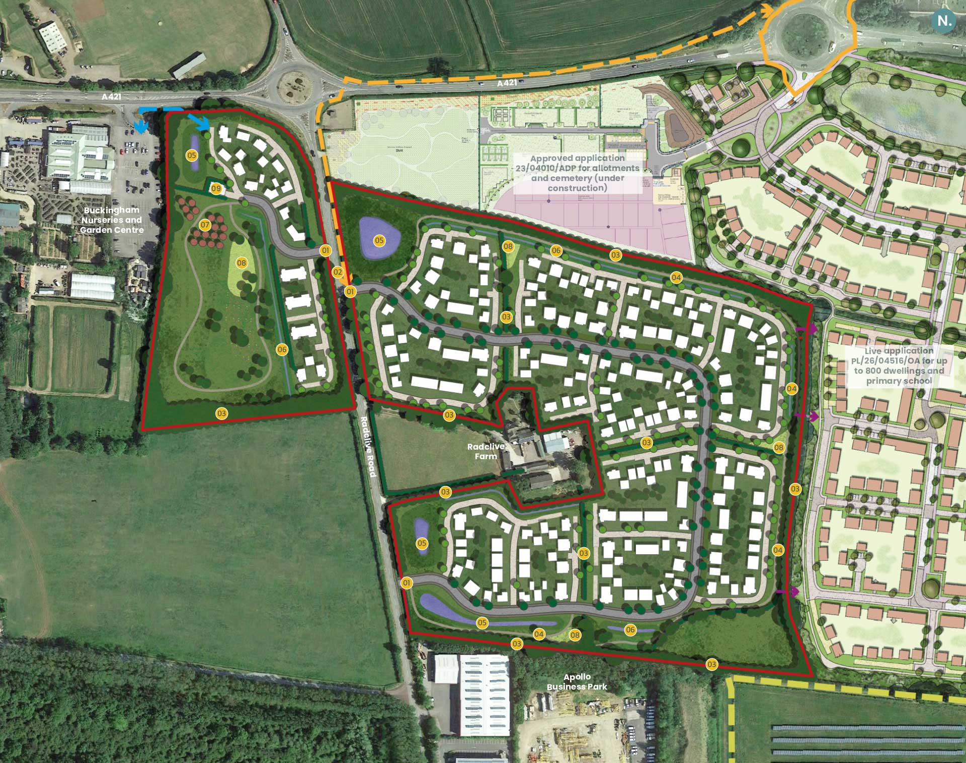

Vehicular, pedestrian, and cycle access point

Crossing point

Retained and enhanced vegetation

Landscape corridor featuring pedestrian and cycle paths

Sustainable Drainage Systems (SuDS)

Swales

Community orchard

Children’s play space

Pumping station

Residential land

Public Right of Way: Footpath

Active travel corridor

Existing pedestrian/cycle facilities

Pedestrian/cycle connection

Local area for play



Access and Movement
The development will be accessed from three new junctions on Radclive Road, which will be delivered alongside pedestrian and cycle improvements to Radclive Road and the A421. A mobility hub is proposed to encourage the use of more sustainable travel choices.
Safe and attractive connections with off-site pedestrian and cycle routes will provide active travel routes both within the site and the neighbouring housing allocation, Buckingham Nurseries & Garden Centre, the Buckingham Green Ring, National Cycle Network Route 50, the town and wider countryside.
Electric Vehicle infrastructure will be included within the design of the new homes and public spaces. A Travel Plan will also be provided for new residents to encourage and support sustainable transport measures.
New Homes
The proposals will deliver a high-quality, sustainable residential development with a range of house-types, including the potential for self-build and custom-build opportunities. 40% of the new homes will be affordable housing.
The development will deliver a mix of houses including homes for families, first-time buyers and downsizers. This will expand housing choice, support demographic diversity and help younger generations remain in Buckingham.
The application will be submitted in outline, with the exact housing mix to be determined at the reserved matters stage.
Green Infrastructure and Biodiversity Net Gain
Approximately 40% of the site will be set aside as green infrastructure, designed to complement the Buckingham Green Ring and achieve at least 10% biodiversity net gain. Key elements include:
- Gateway greens and community orchards;
- Play areas integrated into a network of landscape corridors and spaces;
- Landscape corridors, species-rich meadows and connected wildlife habitats;
- Sustainable drainage (SuDS) features with wetland planting to support biodiversity and manage surface water.
These spaces will promote health and wellbeing, enhance ecological resilience, and complement the adjoining development’s proposed green and blue infrastructure network.
Surface Water Drainage
The site is situated in an area at low risk of flooding (Flood Zone 1). Within the proposals, new surface water balancing ponds are included. These areas will manage surface water runoff and create attractive new green infrastructure features, providing further opportunities for wildlife habitat creation. A Drainage Strategy and Flood Risk Assessment will be submitted with the application.
S.106 Contributions:
Subject to discussions with Buckinghamshire Council, financial contributions to the Local Authority may need to be made to support local infrastructure needs which could include education, health, community, sports and transport improvements.



Next Steps
An outline planning application is expected to be submitted to Buckinghamshire Council during 2026 after comments from this consultation have been considered.
Following the submission of the planning application, the Council will undertake a period of statutory consultation on the application. At this stage you will have the opportunity to submit your comments on the application to the Council before a decision is made.
Feedback
Gallagher Developments looks forward to working with Buckinghamshire Council, key stakeholders and the local community to deliver a well-planned, sustainable neighbourhood that complements the town’s growth strategy.
Thank you for reviewing these proposals. Please take your time to fill in the feedback section.
Please send your feedback by Monday 14 September 2026.
Your details will not be passed to any third-party organisations and will only be used internally by Engage Planning Ltd and Gallagher Developments, for the purposes of understanding your views on the proposals.
Comments made on this form may be used to provide an example of the feedback received, although not attributed, as part of the report of this consultation and the Statement of Community Engagement. For the full privacy statement please see www.engageplanning.co.uk
Further Information:
Engage Planning Ltd, 11 Dormer Place, Royal Leamington Spa, CV32 5AA
Telephone: 01926 623095
Email: info@engageplanning.co.uk
Providing contact details is optional.